![[NAAPO Logo]](../../Images/NAAPOsm.jpg) North American AstroPhysical Observatory (NAAPO)
|
|
A New "Road Map" of the Heavens
A long awaited publication event By: John Kraus
Astronomers and other watchers of the sky now have an atlas of overlay maps with which to identify one-half million celestial objects. Cuhninating years of work, this atlas has just been published by the Ohio State University Radio Observatory.
Locations and designations are given for the brighter stars, clusters of stars, galaxies, clusters of galaxies, planetary nebulas, absorption nebulas, emission nebulas, blue stellar objects, quasistellar objects, supernovas and many other objects. Celestial and galactic coordinate grids are also included.
The new sky atlas is the most comprehensive ever prepared and will be especially useful because it can be directly compared with the photographs of the National Geographic Society Palomar Sky Survey. The comparison is accomplished by printing the atlas maps on special clear plastic overlay sheets of exactly the same size as the Palomar photographs (14 x 17 inches or 36 x 43 cm). There is one such overlay for each of the 1037 different Palomar fields. The overlays give mankind's present knowledge of the heavens in capsule form with each object referred by number to one of the 300 catalogs on which the atlas is based.
A Palomar sky photograph is like an aerial photograph of the Earth: there are many objects but none are identified. The sky overlays permit the immediate identification of one-half million celestial objects like a geographic map made from an aerial photograph identifies cities, towns, roads, lakes and rivers. The original motivation for preparing the overlays was to assist astronomers in establishing the relationship of radio sources to objects appearing on optical photographs. The overlays will greatly facilitate this work.
The overlays were prepared by Robert Dixon, Mirjana Gearhart, and Paul Schmidtke of the Ohio State University Radio Observatory and were produced and distributed by the Observatory on a non-profit basis. Assistance for the project was provided by the National Science Foundation, the National Geographic Society, the Ohio State University and the Ohio Wesleyan University.
Caption for Graphic #1 Below
Sample of about one-tenth of overlay map superimposed on Palomar Plate 1357 and reproduced at actual size (in magazine) showing 3 galactic clusters (symbol large G) with prominent edge-on galaxy (indicated by heavy arrow left of center) and broadside galaxy (indicated by heavy arrow right of center). Individual galaxies (symbol LM ), blue objects (symbol: B) and many stars (symbol: 6 digit number) also are shown. At right is summary table accompanying overlay which gives technical information regarding the photograph (coordinates, scales, exposure data, etc.) and the numbers of various kinds of objects appearing on it. The overlay is displaced slightly (to right and above the photograph) to facilitate comparison of overlay positions with photograph objects.

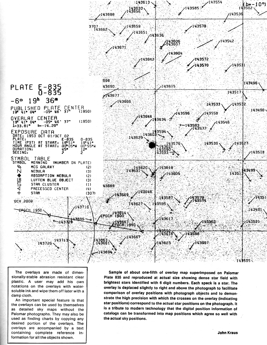
Caption for Graphic #2 Below Sample of about one-fifth of overlay map superimposed on Palomar Plate 835 and reproduced at actual size (in magazine) showing dense star field with brightest stars identified with 6 digit numbers. Each speck is a star. The overlay is deplaced slightly to right and above the photograph to facilitate comparison of overlay positions with photograph objects and to demonstrate the high precision with which the crosses on the overlay (indicating star positions) correspond to the actual star positions on the photograph. It is a tribute to modern technology that the digital position information of catalogs can be transformed into map positions which agree so well with the actual sky positions.
|